File:BowlingGreenConnMap.png
BowlingGreenConnMap.png (512 × 512 pixels, file size: 51 KB, MIME type: image/png)
Summary
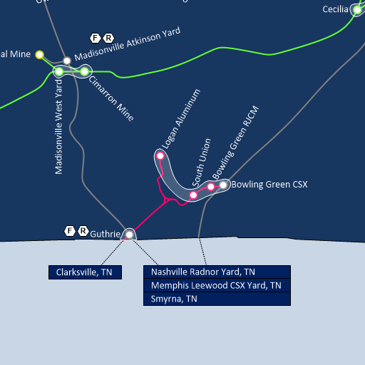
Tutorial 2 - Cutout of the connection map for Kentucky, focusing on Bowling Green, KY. Gray lines and circles indicate CSX routes and maps, while the RJCM is indicated by light pink. The light green is the Paducah and Louisville railroad, which is not involved in this tutorial.
Nashville is to the south, in the adjacent state of Tennessee, while Louisville is to the northeast. Guthrie is located to the southwest, with the associated RJCM branch to Clarksville crossing the border into Tennessee.
Licencing
This work is licensed under the Creative Commons Attribution-Share Alike 2.0 License.
File history
Click on a date/time to view the file as it appeared at that time.
| Date/Time | Thumbnail | Dimensions | User | Comment | |
|---|---|---|---|---|---|
| current | 21:34, 12 February 2020 | | 512 × 512 (51 KB) | Danny252 (talk | contribs) | Tutorial 2 - Cutout of the connection map for Kentucky, focusing on Bowling Green, KY. Gray lines and circles indicate CSX routes and maps, while the RJCM is indicated by light pink. The light green is the Paducah and Louisville railroad, which is not involved in this tutorial. Nashville is to the south, in the adjacent state of Tennessee, while Louisville is to the northeast. Guthrie is located to the southwest, with the associated RJCM branch to Clarksville crossing the border into Tennessee. |
- You cannot overwrite this file.
File usage
The following page links to this file: